Via Wagon Train Trail, June 21, 2008
Elevation Start: 1,800'
Elevation at Double Knob, south summit: 4,040'
Elevation gain: 2,240'
Time Line
Start at red gate behind Rollins Hall at Young Harris College
To Wagon Train Trail (30mins)
Spring at the head of Darr Cove (59mins)
Crest of Double Knob Ridge (1hr 10mins) - this is where you begin bushwhacking.
Found USGS marker at 3,596' el (1hr 35mins)
Double Knobs, north summit (1hr 52mins)
Double Knobs, south summit (2hrs 4mins)
Back to Parking Area (3hrs 26mins)
This trip includes 54 minutes of blazing your own trail through underbrush. Most of Georgia's 4000' peaks are not directly accessible by trail, and involve a bit of bushwhacking. Some bushwhacking trips are more adventurous than others. This one wasn't too terrible other than when a lone hornet drilled into the back of my right calf as I was making my way back down to the trail.
As I pushed my way past laurel and rhododendron bushes, along with the occasional brier patch, I made my way up towards the summit. There is no particular method I use in bushwhacking. The idea is to simply keep going in the direction of up until the highest point is reached. Hopefully a purchase of a hand held GPS in the near future will be of great help for trips like this.
I ascended the north summit from which I could plainly make out the higher south summit. I hate to sound like a broken record on some of these "peakbagging" trips, but the view from either peak is negligible. Both are completely covered with trees. In the near future I plan to do this trip in the winter when the views are completely different than the full foliage of June.
As you can see, coming down is a bit easier than going up, as it took only 1hr 22mins to return to the parking area. The best time to use this trail is when Young Harris College is not in session. With the students gone, there is abundant parking.
Friday, December 24, 2010
Miller Trek Trail
 |
| Trailhead Arch |
Starting Elevation: Miller Trek Trail Head 1,926'
Highest Elevation: 3,315 at Rocky Knob
Climb of 1,389' in the first 3 miles, mostly downhill back to trail head.
Time line
Start at trail head.
Right turn (15 mins) - first hard right off the blue blazed trail.
Pine thicket (19 mins) - after crossing the power cut.
Trail map sign (28 mins) - bear to the right at sign.
Small cove w/bridge (50 mins)
Cross over to south ridge of Rocky Knob (1hr 34mins) - Highest point on trail.
Long bridge (2hrs 11mins) - 100'+ of narrow deck that crosses boggy area.
Back to sign (2hrs 24mins)
Back to power cut (2hrs 39mins)
Trail intersection (2hrs 45 mins)
End back at trail head (approximately 3 hours)
In the mid 1990s, the state of Georgia decided it would be a good idea to build an 18-hole golf course and mountain resort near Young Harris. In addition to the main lodge, there are cabins dotting the hillsides, a spa, horse stables, and tennis courts, spread out over 500+ acres in an area that the Cherokee once referred to as "The Enchanted Valley". To me, the best features of the resort area are the 9 miles of hiking trails that meander through the mountain bogs and up on the ridges behind the main lodge.
The main trail is the Miller Trek Trail (in the process of being changed to lime green blaze trail markers) which begins near the main entrance to the resort at a parking area on the right. The trail head can't be missed as it is an elaborate rock and wooden arch. The trail is named after former Georgia Governor and U.S. Senator Zell Miller. You may remember him as the fellow that challenged Chris Matthews of MSNBC's Hardball to a duel on national television during the coverage of the 2004 Presidential campaign. That bit of craziness aside, he is a resident of Young Harris, went to college there, and is still a very active member in the community.
This trail has become on of my most frequented due to its close location to my home, and the fact that there is a nice loop hike that can be done in about an hour and ten minutes. Also, the two other nearby trails (Arkaquah, and the Wagon Train Trail) are butt kickers for the first 1-2 miles. Sometimes it's nice to walk in the woods without feeling like you might suffer a coronary in the first 1/2 hour. I take the dogs here at least once a week for a change of pace from the neighborhood roads.
On this day we tackled the entire loop trail which, according to the brochure, is 6.5 miles in length. This is a great trail to take dogs on, without having to carry extra water for them. There are many spring branches & creeks for them to drink freely. Just remember that their gut can take drinking from the stream, and yours can't!
Winter time, as with most every hike in North Georgia, is the best time to take in the mountain views. On the return trip, once you have crossed over to the south slope of Rocky Knob, you can see the blue of Lake Chatuge in the direction of Hiawassee, GA. There are no clearings with a stunning vista, but this trail provides a nice ramble through the woods, includes creek bottoms, ridge tops, and all areas in between.
Regarding wildlife, I have seen a black bear on this trail, near the pine thicket, and Deer are also a common sight. However, this day's trip didn't include any wildlife sightings. If you desire a shorter hike, follow the blue blazes on a 2 mile loop trail that includes educational markers about the mountain habitat. Or, do both!
Tuesday, November 30, 2010
Brasstown Bald via Arkaquah Trail 8/29/2010
TIME LINE
3:45 PM start, 2200' elevation
3:55 small spring (10mins)
4:54 Buzzards Roost Ridge overlook, 3640' elevation (1hr 9mins)
5:10 begin ascent from Cove Gap up to Locust Log Ridge (1hr 25mins)
5:25 begin descent from Locust Log Ridge (1hr 40mins)
5:33 rock seat at Low Gap, then ascent (1hr 48mins)
5:50 spring at rock formation on the north side of Blue Bluff (2hrs 5mins)
6:03 ridge with east view (2hrs 18mins)
6:30 rock pass through (2hrs 45mins)
6:35 slab on Chimneytop (2hrs 50 mins)
7:15PM arrive at parking area, 4,320; elevation (3hrs 30 mins)
This is one of my favorite trails in North Georgia. It may be the combination of the tough ascent up to Buzzards Roost Ridge mixed with the ancient Native American history of the Trackrock Gap petroglyphs. Also, the fact that the trail head is a mere 3 1/2 miles from my front door doesn't hurt. The dogs and I have used it many times as a short workout hike, usually trudging up the hour or so that it takes to get to a fine view of the Plott Town and Jacksonville communities.
I first completed this hike to the top of Brasstown Bald on Easter in 2007. This is the first time since then that I have completed the trip all the way to the parking area, which lies .6 miles below the summit. So, if you're looking to make this your trail of choice for ascending Brasstown Bald, add in another 20mins to reach the summit. The Easter hike was an in and out hike that took eight and a half hours to complete. This time again, I had Jennifer pick me up at the parking area so I could enjoy the ride back down, not to mention that darkness would have swallowed me about halfway back.
Like so many of my hikes in this area, the number of people that you pass on the trail is minimal. This day was no exception as I passed a couple and their dog a mere 30 minutes into the hike. From that point on, it was just me and the dogs.
The first hour and nine minutes involved a climb of 1,440' to get up onto the Buzzard Roost Ridge where there is a vantage point from a cluster of boulders where I always like to take a short break. From here, the trail continues along a narrow ridge where you can spy the tower on Brasstown Bald through the treetops. It looks closer than the two hours and a bit that it will take to travel across the ridges and up and down the peaks on the way to the parking area.
In the winter, the views are certainly better than the curtain of green that covers the trees in the summer. Views to the west overlook the Track Rock, Town Creek, and Choestoe Valley areas of the county. I wish there were some bluffs, much like the one on top of Blood Mountain, that would provide a more open view.
Leaving Buzzard Roost Ridge, the trail drops down into Cove Gap, thus beginning a series of ascents and descents until you break out into the open on the rocky top of Chimneytop Mountain (another of the Georgia 4000' peaks). This is also a nice spot to sit and give your legs a rest. From here, the trail is fairly level, taking you through the lush rhododendron and laurel tunnel all the way to the parking area.
The sweat on my body becomes a cold dampness as I break into the open at 4,320' elevation, where even on a late August evening in Georgia the wind makes it cool enough that I'm glad for the fleece stowed away in my pack. I stroll to the far end of the lot near where Jacks Knob Trail comes in from the south. There is a nice view from the picnic area back to the north, where a family is enjoying a late picnic all the while fighting the battle to keep their plates and napkins from blowing away.
As the sun begins to drop behind the ridges to the west, my ride arrives, ending yet another great day of hiking in North Georgia.
Wednesday, October 20, 2010
Coosa Bald, March 15, 2008
Summit Elevation 4,280' - 11th highest in Georgia
Wolfpen Gap Elevation 3,140'
Elevation Gain 1,140'
Time to Summit - 55 minutes

There are a few different approaches to reach this summit. On this day, I chose the Coosa Backcountry Trail at Wolfpen Gap on Ga Hwy 180. Traveling north from this point, you head towards the summit of Coosa Bald. Traveling south you make your way up the steep and rocky trail towards Slaughter Mountain. If you are particularly ambitious, from Wolfpen Gap you can summit Coosa Bald, Slaughter and Blood Mountains all in the same day. The trail at this point is actually a combined trail including the Coosa Backcountry Trail and the Duncan Ridge Trail.
From Wolfpen Gap, the trail rises slightly then turns away from what was obviously the old path, as you could see the blue and yellow blazes continuing straight up the slope. Once in a while, the forest service decides that the old trail is becoming too eroded, thus a new pathway to give the old ground a chance to heal itself. To make sure that no one mistook the old trail for the new, piles of brush or dirt are placed to discourage hikers from following the path. However, at this point, the trees on the newer trail had yet to be adorned with their blazes of blue and yellow to tell me I was on the right path.
After 32 minutes of cutting back and forth (the new path utilizes the natural contour more than the old which appeared to travel straight up and over Wildcat Knob), the new trail re-connected with the old trail on the back side of Wildcat Knob, where the blazes came back into view. Just below this point, the trail intersects with a Forest Road before continuing up the hill to the steepest part of the climb. The trail at this point leaves behind the soft earth which is replaced by loose cobbles. A steady climb of about 17 minutes placed me at the intersection of the Coosa Backcountry Trail with the Duncan Ridge Trail. If you take this right turn, you will wind your way back down off of the slope and end up at W. Wolf Creek Road, heading in a direction toward Sunrise Grocery and GA Hwy 129.
My aim is to reach the summit, so I continue straigh ahead on the Duncan Ridge Trail. From this intersection it only took me 6 minutes to reach the summit, where there is a very small area of granite that provides a view to the west. Most noticeable about Coosa, like the other Balds, is that they aren't really bald. I assume that many years ago, when the names were assigned, the timber was stripped off the mountaintops thus giving them their names.
Currently there are many hardwoods atop Coosa which surely contributes to the lack of a vista in the summer. But, I am here without foliage and enjoy the views that can be seen through the trees. From the granite slab, the view is in the direction of Suches, GA, and to the left I can make out Slaughter and Blood Mountains, with the top of the latter obscured by clouds.
The wind picked up as I sat down on the rock to take a break. I notice a mountainous wave of clouds approaching from the west, covering far off peaks one by one. I knew before I began this hike that a storm front was approaching. I just thought that they would arrive later in the day. In a matter of minutes, my hike in partly cloudy conditions becomes a near white out.
After quickly eating a banana, taking a couple of pictures, and situating my day pack, I re-trace my steps back down the mountain. Almost simultaneously, it began to lightly rain. A few yards later, I am shaken by a loud thunderclap. Great. I pick up the pace, figuring my car to be a much safer place than a ridge top. Three or four more thunderclaps and the rain intensifies, as my pace does accordingly. In all of natures wrath, I hear the distinct gobble of a Tom Turkey. I guess even a storm doesn't interfere with the task of impressing a hen.
I finally made it to my car, happy to be sheltered from the bad weather. The night before, a tornado interrupted the mens SEC Basketball Tournament by trying to rip the roof off the Georgia Dome. This day was a continuation of that weather pattern which ended up as the most tornado filled day in North Georgia history! Nevertheless, a great day for a hike.

Thursday, August 5, 2010
Sweltering Summer
Even though the North Georgia mountain region is known for being an escape from the heat of the Piedmont, Sand Hills, and Coastal Plains regions of the state, this summer has seemed hotter than usual. Or, maybe as my body ages, it just doesn't handle the heat as well. Or, it's that extra 30 lbs I've managed to pack on since last summer.
Earlier in the season we had plenty of rain that managed to keep the air fresh and the temperatures down somewhat. But, for the past month it has been too hot for me to feel like doing anything beyond my never ending yard work.
My goal of attaining the summits of all of the 4000' peaks in Georgia requires bushwhacking, on many occasions, in order to reach the top. Doing this in the summer months involves a lot of contact with briers, which tend to win the battle against the flesh of my legs. I still have scars from the summer of 2008! This is an activity best left for fall and winter once the vegetation has died back a bit.
Without any new ridge walking tales to tell, the next few posts are going to focus on hikes that I have taken and documented in the past three years. The majority of these took place in North Georgia, and include many of the 4000' peaks listed on peakbagger.com.
So, until I get back out there in real time, enjoy some history...coming soon!
Wednesday, May 26, 2010
Brasstown Bald

On April 11, 2010, I did get a chance to hike with the super dogs, Rocket (L) and Tobey (R), up the Wagon Train Trail from Young Harris College to the top of Brasstown Bald. It was about a 6-mile excursion, and not wanting to take the time to hike back down the way we came, I arranged for Jennifer to meet us in the parking lot for a ride back home. It was an absolutely gorgeous day.
During the entire trek, that took about 4 hours, we passed one person on the trail. It was an interesting encounter. At around one mile from the parking area, around the bend came a fellow that was dressed head to toe in camouflage, including face paint. He was carrying what looked like a wooden bow with some arrows. Grinning like a jack-o-lantern, he commented, "Those are some nice dogs". I thanked him and kept heading up, in paranoid fashion waiting to hear the sound of an arrow slicing through the air just before it ripped into my back. Not this time, anyway. It was Turkey season, which if I had known this before, his presence wouldn't have seemed so odd.
I am going to try to share more of the informational aspects of my hikes as I post on here. As I'm hiking I like to make notes of interesting features or views and at what point they occur on the trail. I am a moderate to slow hiker, so feel free to use these as an informal guide depending on your own speed.
The following represents the time line of the hike:
9:15AM - Begin up gravel road at Young Harris College
9:32 - Large rock outcrop on the left.
9:43 - Reached the Wagon Train trail head.
10:17 - Spring branch at head of Darr Cove.
10:29 - Spine of Double Knob Ridge.
10:54 - Spring branch.
11:08 - Another spring branch (from here on to Buck Ridge, the trail frequently turned into a flowing branch. It has been a very wet year!)
11:38 - Spine of Buck Ridge.
11:55 - Great vista of the tower on Brasstown Bald (see photo at top).
12:20PM - Gap with a view to the East, overlooking Grass Branch Cove.
12:35 - Views to the NW.
12:49 - Gap with views of Chestnut Cove.
1:15 - Intersection with paved path that leads to the summit.
1:20 - Parking area.
The dogs and I laid down on a grassy area next to the parking lot, enjoyed some water and waited, while soaking up the sun, for our ride to arrive.
Our next trek will be up the Arkaquah Trail to the summit, again with a ride down. At some point later this summer, I hope to go up this trail and down the Wagon Train Trail in a one-day trip. It will be about 13 miles, and yes, I plan on being shuttled home after that one.
Friday, April 2, 2010
Trout Lily and Sweet Betsy Make Their Return
Springtime has taken over North Georgia. Beginning a few weeks ago I noticed in full bloom, the Daffodils and Redbuds. This week I have spied an explosion of color from Forsythia, Bradford Pear trees, Yoshino Cherry trees, and Japanese Magnolias, amongst others. At home, I have eagerly been watching to see if the many perennials that were planted last year would make their return.
Hyacinths, Tulips, Hostas, Cone Flower, Hydrangea, Rasberry, and Blackberry bush have all begun to poke their green heads out of the ground. Last year, we ordered a couple of Forsythias from the Arbor Day Foundation, and laughed when two sticks arrived in the mail. I know, what did I expect for less than $3 each? They were planted one on either side of the driveway with the expectation that we would be enjoying a beachball sized plume of yellow by the next spring.
Well, they really didn't grow at all over the summer or winter. In fact it got to the point that I just knew they were dead. I mean, they looked like lifeless twigs that had been haphazardly stuck into the ground. We also transplanted, from Mobile, several Cast Iron Plants late last summer. With the unusually cold winter that we've had, they all turned a sickly light brown color, and some of them simply laid down flat and gave up.
Low and behold, both of the Forsythia have new green buds (maybe they'll get plumes the size of a baseball), and a couple of the Cast Iron plants have new growth poking out near the base. I was very excited (it doesn't take much) at these revelations.
On the wild side of things, a true sign that spring has arrived in when the ground near the spring branch becomes covered with Trout Lilies and Sweet Betsy's. They are the first of the wildflowers to be spotted once winter has released its harsh grip.
Soon, the Mayapple and the Trillium will sprout, the trees will fill with leaves and the curtain will be drawn, shutting off my view of Brasstown Bald. Now is the time to dig out briers before they take over. It's time to mulch the flower beds. Before you know it, the vegetable gardening will begin, and none too soon. We are almost out of salsa.
Fall is my first love, but Spring is a very close second.
Friday, March 26, 2010
Yellow-rumped Warbler!
March 6, 2010 - While taking a stroll along the Augusta Canal Heritage Area (near the pumping station) with some family members, I spotted a small bird flitting from branch to branch in a budding Red Maple. A quick glance through the binoculars revealed distinct yellow spots on either sides of its breast. A check of the bird book later identified it as a Yellow-rumped Warbler. According to the website Whatbird.com, it is one of the most common Warblers in North America.
Yellow-rumped Warbler, bird number 46.
Yellow-rumped Warbler, bird number 46.
Wednesday, March 24, 2010
Mobile, AL Mardi Gras and A Few Birds.
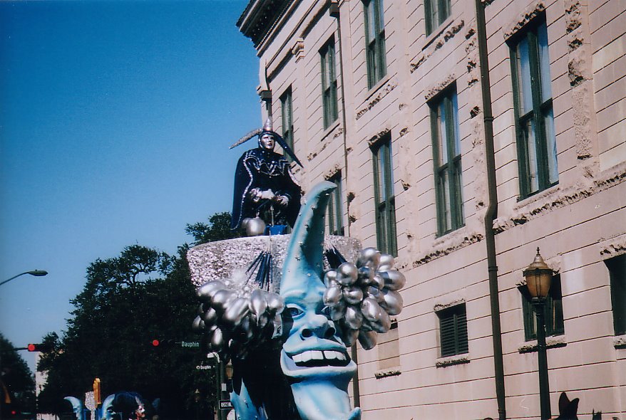
After my Cheaha Mountain trek, I headed south through small town Alabama, including Shinbone, Lineville, Equality, and Wetumpka, before hitting Montgomery and hopping on I-65. From there is was 177 miles of some pretty flat and swampy terrain before hitting the city limits of Mobile.
Most people think of New Orleans when the subject of Mardi Gras comes up. Mobile actually has the oldest Mardi Gras celebration in America, beginning in 1703. New Orleans wasn't even founded until 1718.
During my week long stay I attended 15 Mardi Gras Parades, and was pelted with various items slung from the floats including frisbees, stuffed animals, bags of roasted peanuts, Mary Janes, Super Bubble, plastic doubloons, Moon Pies, and of course, beads. Lots of beads. Considering the volume of items flung in my direction, it's surprising that I only got smacked in the face once. A set of beads found their mark on the bridge of my nose. By Fat Tuesday, I was paraded out.
As a break from the parades, on Sunday Jennifer and I headed south to Dauphin Island to ride the ferry across Mobile Bay from Fort Gaines on Dauphin Island to Fort Morgan and Gulf Shores. During this outing, I spotted two new birds to add to my list, a Cedar Waxwing (seen at the Alabama Coastal Birding Trail #42) and a Royal Tern (seen at the ferry landing on Dauphin Island). I would have added more, but I forgot my binoculars like a dope. Later that week I also spotted a Boat Tailed Grackle in some reeds after I dined on some fine fried shrimp at Ed's Seafood on the Mobile Causeway. So, three birds when I hoped for ten. I'll take that.
I enjoyed my first visit to this area and look forward to a return trip....without forgetting the binoculars.

Mobile Bay from Dauphin Island (Including natural gas rigs in the distance, they are everywhere, as far as the eye can see!)
Wednesday, March 17, 2010
A Hike Down, Then Up To the Summit.

Feb 11, 2010 - As the light barely began to filter through the window of my room, I rose at about 5:30AM and drove up to the picnic area near the summit. Here I shivered in the frigid wind while taking pictures of an absolutely inspiring sunrise. I was ready to hit the trail.
After considering my all of my options, it was decided that the Lake Trail/Rock Gardens Trail would be the most difficult approach considering the fact that I had an 11:00AM checkout time. My ascent (which actually begins as a descent) began at the loop road for cabins 7, 8, 9, and 10. This is where the Lake Trail/Rock Gardens Trail begins. Granted, it's not a long hike, but again, like Chinnabee, it was very rocky at the top (thus the Rock Gardens name). The views from the Rock Gardens on this morning were gorgeous. In the photo below you can see the lake in the background, to the left of one of the granite crags of the Rock Gardens.

Down 1200' I went traveling through granite boulder fields, hardwood forest with a couple of small creek crossings, until I reached the shoreline of the lake 45 minutes later. After taking a few pictures of the mountain from the lake, I began my ascent going the same way I came down. This trail is not for those that have issues with steep, rocky (boulders) trails. A 1200' elevation change in one mile is no picnic.
Once I got back up to the car, I continued across the road and bushwhacked my way up the ridge until I came out at the campground near the group picnic shelter. From here it was a walk on the asphalt until I reached the high point. The observatory tower wasn't open and I walked around until I found the USGS marker identifying the high point. My travel time from the lake to the summit took one hour and sixteen minutes.

(above) View of Cheaha Mountain (high point at tower) from Cheaha Lake
This time of year in this park was ideal for me. Though it may seem anti-social, the fewer people I run into on the trails, the better. In my almost 24 hours spent in the park, I ran across a total of two people, none on the trails. I basically had the park to myself. I definitely plan on returning, as I hope to finish my hike to the summit using the Chinnabee Silent Trail and the Pinhoti Trail.
If you ever find yourself traveling I-20 between Atlanta and Birmingham, I definitely recommend that you detour south and visit Cheaha State Park. Like most state parks, the facilities are obviously suffering from budget cuts, and the place really needs a bit of a makeover (unfortunately, the summit tower sits right beside the ugliest, run down, junky looking communications tower facility), but once you are on the trails, the variety of terrain from boggy pine bottoms, to talus strewn side slopes bisected by clear flowing streams, to granite boulder ridge tops, is wonderful. Check it out.
Wednesday, February 24, 2010
Chinnabee Silent Trail

TALUS ON CHINNABEE SILENT TRAIL
I have finally recovered enough to check in here and give a few details about my latest adventure. Ok, so the truth is that it's been more of a case of the lazies, than a need to recover.
Feb 10, 2010 - I arrived at the park a little after noontime, and by the time I checked into the lodge, got my gear together and studied the trail map, it was already early afternoon. One of my requirements in reaching the state high points is that the hike cannot be the easiest route to the top. Many of the states highest peaks have been turned into attractions that the general public can take advantage of by accessing the area by vehicle. Mounts Washington, Greylock, Brasstown Bald, Clingmans Dome, all have roads that lead to, or nearly to the summit. In my mind, to go this route and claim it as an ascent of the mountain is akin to cheating. I want each summit to require more effort than a drive and a walk on a paved path to the top.
With this in mind, I decided the best way to "work" for the summit would be to travel south down Hwy 281 to where the Chinnabee Silent Trail crosses the road, and access the Pinhoti Trail via the Chinnabee Silent Trail, then hike north.
The Chinnabee Silent Trail proved to be a difficult, but beautiful climb, with the last 1/2 traveling through a very rocky, talus strewn landscape. By the time I reached the Pinhoti Trail ( 1 hr 17 mins), it was obvious that the trip to Cheaha Mountain, plus the return, could not be accomplished by dark. I thought about continuing the hike, sleeping in the lodge, then hiking back to the car in the morning. However, posts on the web about cars left overnight being vandalized in this area made me decide against that.
I walked north on Pinhoti for a while, then back to the trail intersection where I hiked east on the Odum Scout Trail for about 20 minutes out and back. I was hoping for a scenic overlook to the southeast, with no luck. Obviously, I didn't travel far enough as I have since read that there are some spectacular views from this trail. Eventually I retraced my steps to the car and drove back north to the lodge and enjoyed the sunset from the deck of the empty restaurant. The wind was whipping and added an extra chill to the already frigid air.
After snapping a few photos, I retreated to the warmth of my room, thankful that I wasn't going to weather the cold wind all night in a tent. I dined on a banana, some wheat thins and roasted peanuts while studying the park maps and began plotting my route up to the Cheaha summit for the next morning.

SUNSET LOOKING SW FROM CHEAHA MOUNTAIN
Wednesday, February 10, 2010
Cheaha Mountain, here I come!
I'm headed to Cheaha Mountain (AL) to check off state high peak number seven. I have previously bagged New Hampshire (Mount Washington), Vermont (Mount Mansfield), Massachusetts (Mount Greylock), Connecticut (Bear Mountain), Georgia (Brasstown Bald), and Tennessee (Clingmans Dome).
After Alabama, I still have NC, SC, VA, KY, WV, MD, PA, NJ, NY, & ME to go on my quest to hike the highest peaks in every state that includes part of the Appalachian Mountain Range.
Following a day or so of hiking, it's off to Mobile, AL for some Mardi Gras parades and some Moon Pie catching. I also hope to add at least 10 birds to my list on this trip. I'll report soon!
Sunday, February 7, 2010
Benton MacKaye and Duncan Ridge Trails

After a day of on and off sleet and snow flurries, the curtain of clouds peeled back far enough to see the ridge tops near Brasstown Bald. The higher elevations definitely had snow and the trees were coated with rime. A good hike before the Superbowl was exactly what I needed before settling into three plus hours of football and commercials.
One of the main trails in this area that I haven't trekked on was the Benton MacKaye Trail. The trail begins atop Springer Mountain and follows the Appalachian Trail before peeling off to the north and west going into Tennessee and North Carolina. A fellow hiker recommended a nearby section so I decided today was as good a day as any to check it out.
My trip began as I parked on the side of Skeenah Gap Road at the border of Union and Fannin County. The trail is easily missed as there are no signs other than the small trail markers to let you know it's there. The parking area consists of a hard shoulder on the south side of the road. From here I headed south on my way to the summit of Rhodes Mountain.
I don't know what the elevation is at this point, but it didn't take long before I found myself surrounded by rime. This direction is mainly an ascent, not terribly hard, but a good workout nonetheless. Not until you get near the intersection with the Duncan Ridge Trail (1.5 miles) do you find some downhill relief. Taking a left at this intersection, it is a short climb up to the Rhodes summit via the Duncan Ridge Trail.
The ice was thick on the vegetation with about an inch of snow on the ground. And, of course, there was a considerable amount of fog and the vistas for the most part remained shrouded. At the summit, there is a nice open area where I caught a glimpse of the opposing ridge (see top photo).
Wildlife spotted: Several Carolina Chickadees; a Raven harassing an unidentified hawk; and, not exactly spotted, but a Bobcat and a rabbit had evidently used the trail that morning. For the rabbit's sake, not at the same time. It was pretty quiet as most creatures were probably bedded down in a warm spot.
I'm definitely gonna do this stretch again. Next time, on a blue sky day.

Tuesday, February 2, 2010
Arkaquah Trail at Trackrock Gap

Taking advantage of one of the few dry days as of late, I decided to rush home after work yesterday and take the dogs on a workout hike. Our workout hikes consist of 1 to 1 1/2 hours on a trail, usually without a day pack unless it's summertime when water is needed. These small hikes give me a chance to get off of the pavement and into the woods, mostly for a change of scenery, but also to really work those hamstrings and calves on the ascents and the front of the thigh on the descents.
Of the three trails located conveniently close to the home, two of them involve tough uphill approaches that last about two miles before any relief is offered. The third trail is the one where I was nearly disemboweled last time out (see previous post), so I figured I better wait until ALL of the downed trees have been removed from the path before I go that route again.
I didn't feel like fighting the students of Young Harris College for a parking space and it had been a while since I tackled the uphill meat grinder of the Arkaquah Trail at Trackrock Gap. So, I loaded up the dogs and made it over to the trailhead parking area and we were on the trail by 5:05PM. I love this time of year because the days are progressively getting longer and the light in the early evening is fantastic as it illuminates the bare naked forest of tree shafts and rock formations.
Trackrock Gap is a well known (well, mostly in archaeologic circles) site of the only petroglyphs in Georgia that remain in their original location. These rocks contain the carvings of pre-European people that are estimated to have existed as far back as 9000 B.C., or as recently as the Cherokee Tribe in 1500 A.D. (read the historical marker is the photo for more on this site)
Whichever group did these carvings, I like to imagine their presence as I look around the area that I am hiking, wishing I could go back in a time machine to the days of the virgin, unspoiled forest, a woodland teeming with animals, clean water and native people. I get the same feeling when I find an arrowhead. It blows my mind to think that I am holding something that may pre-date the voyages of the Vikings or Christopher Columbus.
As we snake our way around the lower portions of Buzzards Roost Ridge, we top a hill that gives a commanding view of a small cove that runs east to west and contains a small spring branch in the bottom. Across the cove, the dogs notice a trio of white tailed deer scrambling up the far side of the cove. They get about half-way up then freeze, literally blending into the surrounding woods. Rocket begins to bay and they take off again, white tails flashing as they pass over the ridge and out of sight. This will be the only wildlife we see today.
After climbing for about 40 minutes, the trail begins to get a lot steeper, with a light snow cover left over from Friday night. That combined with the rain from this weekend began causing me to slip periodically. This and the setting sun made me decide it was time to turn back. On the way back down I decided to leave the trail and cross over a couple of ridges and bushwhack our way down the opposite side of the cove. Once we reached the southern overlook of the ridge, I could see through the naked forest, Coosa Bald, Slaughter Mountain, and Blood Mountain, with their tops partially shrouded with clouds. I wish we had time to just sit and watch as the clouds formed and rolled over the mountain tops, but darkness was chasing us.
We continued down the ridge until we again met the trail on the south side of the cove. The dogs really like going off trail and I don't mind as long as the underbrush is not too thick. It allows me to keep a trail that I have traveled several times from being ordinary.
Back at the car by 6:10PM it was time to head home to collect our rewards of dog treats for them, and a Blackberry smoothie for me. A great workout hike in one of my favorite places, with no serious injuries, for which I am grateful.
Tuesday, January 26, 2010
The Trail is Closed for a Reason.

The Saturday night before last brought some particularly strong wind to the Brasstown Valley. By the next morning, several trees reached the end of their life cycle. The combination of saturated soil and high winds is never a good thing for those trees with weaker root systems. When I arrived for a short hike with the dogs on Sunday, I was disappointed to see the sign that plainly stated "Trail is closed due to downed trees and hazardous conditions." Disappointed, we got back in the car and headed to another destination.
Well, last Saturday I again arrived at the trailhead hoping that it would be open, but the sign was still up. I wondered, 'How bad can it be?' and decided to throw caution to the wind and headed down the path with the two dogs leading the way. We didn't get very far when we came upon a downed pine that blocked the trail entirely and forced us to swing very wide through the underbrush before returning to the open path. Taking two 80 lb dogs on leashes, through underbrush is no picnic. They never seem to guess correctly on the path I wish to take.
We staggered our way around a couple more of these road blocks when we came upon a double hurdle. The dogs passed over the first one pretty easily. On the second one, the dogs failed to consider that their master couldn't quite get over the first one with the grace and speed of a four-legged animal.
They lunged over the second one as the very tip of my boot hung on the first one. The combination of their exuberance and my plodding led to a quick belly flop onto the second tree. Unfortunately this tree had some broken branches sticking up like stakes. I managed to fall, very quickly, taking one of these stakes right into my abdomen, then dropped chest first onto the ground. The dogs simply looked back with expressions of, 'why'd we stop?' or 'is it treat time already?'. They aren't the sympathetic type.
I knew that I fell hard, but my vanity always requires that I pop up and dust myself off as quickly as possible. On down the trail we went and finished up our one hour workout hike without another such incident.
It wasn't until I got home that I realized that my stomach was really hurting, and for good reason. The limb/stake actually tore a hole through my fleece and ripped a large hole in my t-shirt underneath. The photo below shows you the damage done to my flesh (sorry for those of you that don't want to see such a doughboy belly).
Luckily, it was a glancing blow that was more blunt-force trauma than flesh ripping puncture. When the sign says Trail Closed, heed the warning and go hike somewhere else.

Sunday, January 3, 2010
Knoxville, TN

This wasn't exactly a ridge walking adventure, but it did involve a part of the southern Appalachians. I took a drive up to Knoxville, TN for a couple of reasons:
1. Because I had never been there before.
2. To sample some eats from a little soul food place called Chandler's Deli.
I decided to travel Hwy 129 north, which ended up being slightly hazardous. At the higher elevations north of Robbinsville, NC, it was snowing lightly, but it was enough to require caution and a lot of slow driving. At one point we sat for about 10 minutes as a car was pulled back onto the road after some unfortunate driver slid a little down the mountain. Seeing that made me a little nervous and more cautious.
Once we got there, the food was pretty good. I had a fried chicken breast, a pork rib (sold individually for $1.80 each), broccoli and cheese casserole, mac & cheese, and green beans. Downtown Knoxville seems to be undergoing a revitalization process with a lot of projects. Great architectural structures of different eras. Lots to see. I just wish we had more time, and plan on coming back for an over night stay at some point.
We thought we'd be smart and take a different route back, only to get detoured by a rock slide east of Cleveland, TN on Hwy 64. This added about 100 miles to our trip. It's safe to say that there is no easy way to get from NE Georgia to Knoxville.
Subscribe to:
Posts (Atom)