March 6, 2010 - While taking a stroll along the Augusta Canal Heritage Area (near the pumping station) with some family members, I spotted a small bird flitting from branch to branch in a budding Red Maple. A quick glance through the binoculars revealed distinct yellow spots on either sides of its breast. A check of the bird book later identified it as a Yellow-rumped Warbler. According to the website Whatbird.com, it is one of the most common Warblers in North America.
Yellow-rumped Warbler, bird number 46.
Friday, March 26, 2010
Wednesday, March 24, 2010
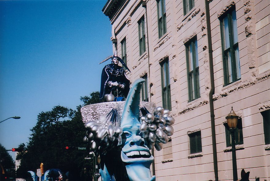
Mobile, AL Mardi Gras and A Few Birds.
After my Cheaha Mountain trek, I headed south through small town Alabama, including Shinbone, Lineville, Equality, and Wetumpka, before hitting Montgomery and hopping on I-65. From there is was 177 miles of some pretty flat and swampy terrain before hitting the city limits of Mobile.
Most people think of New Orleans when the subject of Mardi Gras comes up. Mobile actually has the oldest Mardi Gras celebration in America, beginning in 1703. New Orleans wasn't even founded until 1718.
During my week long stay I attended 15 Mardi Gras Parades, and was pelted with various items slung from the floats including frisbees, stuffed animals, bags of roasted peanuts, Mary Janes, Super Bubble, plastic doubloons, Moon Pies, and of course, beads. Lots of beads. Considering the volume of items flung in my direction, it's surprising that I only got smacked in the face once. A set of beads found their mark on the bridge of my nose. By Fat Tuesday, I was paraded out.
As a break from the parades, on Sunday Jennifer and I headed south to Dauphin Island to ride the ferry across Mobile Bay from Fort Gaines on Dauphin Island to Fort Morgan and Gulf Shores. During this outing, I spotted two new birds to add to my list, a Cedar Waxwing (seen at the Alabama Coastal Birding Trail #42) and a Royal Tern (seen at the ferry landing on Dauphin Island). I would have added more, but I forgot my binoculars like a dope. Later that week I also spotted a Boat Tailed Grackle in some reeds after I dined on some fine fried shrimp at Ed's Seafood on the Mobile Causeway. So, three birds when I hoped for ten. I'll take that.
I enjoyed my first visit to this area and look forward to a return trip....without forgetting the binoculars.

Mobile Bay from Dauphin Island (Including natural gas rigs in the distance, they are everywhere, as far as the eye can see!)
Wednesday, March 17, 2010
A Hike Down, Then Up To the Summit.

Feb 11, 2010 - As the light barely began to filter through the window of my room, I rose at about 5:30AM and drove up to the picnic area near the summit. Here I shivered in the frigid wind while taking pictures of an absolutely inspiring sunrise. I was ready to hit the trail.
After considering my all of my options, it was decided that the Lake Trail/Rock Gardens Trail would be the most difficult approach considering the fact that I had an 11:00AM checkout time. My ascent (which actually begins as a descent) began at the loop road for cabins 7, 8, 9, and 10. This is where the Lake Trail/Rock Gardens Trail begins. Granted, it's not a long hike, but again, like Chinnabee, it was very rocky at the top (thus the Rock Gardens name). The views from the Rock Gardens on this morning were gorgeous. In the photo below you can see the lake in the background, to the left of one of the granite crags of the Rock Gardens.

Down 1200' I went traveling through granite boulder fields, hardwood forest with a couple of small creek crossings, until I reached the shoreline of the lake 45 minutes later. After taking a few pictures of the mountain from the lake, I began my ascent going the same way I came down. This trail is not for those that have issues with steep, rocky (boulders) trails. A 1200' elevation change in one mile is no picnic.
Once I got back up to the car, I continued across the road and bushwhacked my way up the ridge until I came out at the campground near the group picnic shelter. From here it was a walk on the asphalt until I reached the high point. The observatory tower wasn't open and I walked around until I found the USGS marker identifying the high point. My travel time from the lake to the summit took one hour and sixteen minutes.

(above) View of Cheaha Mountain (high point at tower) from Cheaha Lake
This time of year in this park was ideal for me. Though it may seem anti-social, the fewer people I run into on the trails, the better. In my almost 24 hours spent in the park, I ran across a total of two people, none on the trails. I basically had the park to myself. I definitely plan on returning, as I hope to finish my hike to the summit using the Chinnabee Silent Trail and the Pinhoti Trail.
If you ever find yourself traveling I-20 between Atlanta and Birmingham, I definitely recommend that you detour south and visit Cheaha State Park. Like most state parks, the facilities are obviously suffering from budget cuts, and the place really needs a bit of a makeover (unfortunately, the summit tower sits right beside the ugliest, run down, junky looking communications tower facility), but once you are on the trails, the variety of terrain from boggy pine bottoms, to talus strewn side slopes bisected by clear flowing streams, to granite boulder ridge tops, is wonderful. Check it out.
Subscribe to:
Posts (Atom)