Springtime has taken over North Georgia. Beginning a few weeks ago I noticed in full bloom, the Daffodils and Redbuds. This week I have spied an explosion of color from Forsythia, Bradford Pear trees, Yoshino Cherry trees, and Japanese Magnolias, amongst others. At home, I have eagerly been watching to see if the many perennials that were planted last year would make their return.
Hyacinths, Tulips, Hostas, Cone Flower, Hydrangea, Rasberry, and Blackberry bush have all begun to poke their green heads out of the ground. Last year, we ordered a couple of Forsythias from the Arbor Day Foundation, and laughed when two sticks arrived in the mail. I know, what did I expect for less than $3 each? They were planted one on either side of the driveway with the expectation that we would be enjoying a beachball sized plume of yellow by the next spring.
Well, they really didn't grow at all over the summer or winter. In fact it got to the point that I just knew they were dead. I mean, they looked like lifeless twigs that had been haphazardly stuck into the ground. We also transplanted, from Mobile, several Cast Iron Plants late last summer. With the unusually cold winter that we've had, they all turned a sickly light brown color, and some of them simply laid down flat and gave up.
Low and behold, both of the Forsythia have new green buds (maybe they'll get plumes the size of a baseball), and a couple of the Cast Iron plants have new growth poking out near the base. I was very excited (it doesn't take much) at these revelations.
On the wild side of things, a true sign that spring has arrived in when the ground near the spring branch becomes covered with Trout Lilies and Sweet Betsy's. They are the first of the wildflowers to be spotted once winter has released its harsh grip.
Soon, the Mayapple and the Trillium will sprout, the trees will fill with leaves and the curtain will be drawn, shutting off my view of Brasstown Bald. Now is the time to dig out briers before they take over. It's time to mulch the flower beds. Before you know it, the vegetable gardening will begin, and none too soon. We are almost out of salsa.
Fall is my first love, but Spring is a very close second.
Friday, April 2, 2010
Friday, March 26, 2010
Yellow-rumped Warbler!
March 6, 2010 - While taking a stroll along the Augusta Canal Heritage Area (near the pumping station) with some family members, I spotted a small bird flitting from branch to branch in a budding Red Maple. A quick glance through the binoculars revealed distinct yellow spots on either sides of its breast. A check of the bird book later identified it as a Yellow-rumped Warbler. According to the website Whatbird.com, it is one of the most common Warblers in North America.
Yellow-rumped Warbler, bird number 46.
Yellow-rumped Warbler, bird number 46.
Wednesday, March 24, 2010
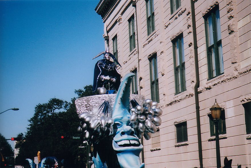
Mobile, AL Mardi Gras and A Few Birds.
After my Cheaha Mountain trek, I headed south through small town Alabama, including Shinbone, Lineville, Equality, and Wetumpka, before hitting Montgomery and hopping on I-65. From there is was 177 miles of some pretty flat and swampy terrain before hitting the city limits of Mobile.
Most people think of New Orleans when the subject of Mardi Gras comes up. Mobile actually has the oldest Mardi Gras celebration in America, beginning in 1703. New Orleans wasn't even founded until 1718.
During my week long stay I attended 15 Mardi Gras Parades, and was pelted with various items slung from the floats including frisbees, stuffed animals, bags of roasted peanuts, Mary Janes, Super Bubble, plastic doubloons, Moon Pies, and of course, beads. Lots of beads. Considering the volume of items flung in my direction, it's surprising that I only got smacked in the face once. A set of beads found their mark on the bridge of my nose. By Fat Tuesday, I was paraded out.
As a break from the parades, on Sunday Jennifer and I headed south to Dauphin Island to ride the ferry across Mobile Bay from Fort Gaines on Dauphin Island to Fort Morgan and Gulf Shores. During this outing, I spotted two new birds to add to my list, a Cedar Waxwing (seen at the Alabama Coastal Birding Trail #42) and a Royal Tern (seen at the ferry landing on Dauphin Island). I would have added more, but I forgot my binoculars like a dope. Later that week I also spotted a Boat Tailed Grackle in some reeds after I dined on some fine fried shrimp at Ed's Seafood on the Mobile Causeway. So, three birds when I hoped for ten. I'll take that.
I enjoyed my first visit to this area and look forward to a return trip....without forgetting the binoculars.

Mobile Bay from Dauphin Island (Including natural gas rigs in the distance, they are everywhere, as far as the eye can see!)
Wednesday, March 17, 2010
A Hike Down, Then Up To the Summit.

Feb 11, 2010 - As the light barely began to filter through the window of my room, I rose at about 5:30AM and drove up to the picnic area near the summit. Here I shivered in the frigid wind while taking pictures of an absolutely inspiring sunrise. I was ready to hit the trail.
After considering my all of my options, it was decided that the Lake Trail/Rock Gardens Trail would be the most difficult approach considering the fact that I had an 11:00AM checkout time. My ascent (which actually begins as a descent) began at the loop road for cabins 7, 8, 9, and 10. This is where the Lake Trail/Rock Gardens Trail begins. Granted, it's not a long hike, but again, like Chinnabee, it was very rocky at the top (thus the Rock Gardens name). The views from the Rock Gardens on this morning were gorgeous. In the photo below you can see the lake in the background, to the left of one of the granite crags of the Rock Gardens.

Down 1200' I went traveling through granite boulder fields, hardwood forest with a couple of small creek crossings, until I reached the shoreline of the lake 45 minutes later. After taking a few pictures of the mountain from the lake, I began my ascent going the same way I came down. This trail is not for those that have issues with steep, rocky (boulders) trails. A 1200' elevation change in one mile is no picnic.
Once I got back up to the car, I continued across the road and bushwhacked my way up the ridge until I came out at the campground near the group picnic shelter. From here it was a walk on the asphalt until I reached the high point. The observatory tower wasn't open and I walked around until I found the USGS marker identifying the high point. My travel time from the lake to the summit took one hour and sixteen minutes.

(above) View of Cheaha Mountain (high point at tower) from Cheaha Lake
This time of year in this park was ideal for me. Though it may seem anti-social, the fewer people I run into on the trails, the better. In my almost 24 hours spent in the park, I ran across a total of two people, none on the trails. I basically had the park to myself. I definitely plan on returning, as I hope to finish my hike to the summit using the Chinnabee Silent Trail and the Pinhoti Trail.
If you ever find yourself traveling I-20 between Atlanta and Birmingham, I definitely recommend that you detour south and visit Cheaha State Park. Like most state parks, the facilities are obviously suffering from budget cuts, and the place really needs a bit of a makeover (unfortunately, the summit tower sits right beside the ugliest, run down, junky looking communications tower facility), but once you are on the trails, the variety of terrain from boggy pine bottoms, to talus strewn side slopes bisected by clear flowing streams, to granite boulder ridge tops, is wonderful. Check it out.
Wednesday, February 24, 2010
Chinnabee Silent Trail

TALUS ON CHINNABEE SILENT TRAIL
I have finally recovered enough to check in here and give a few details about my latest adventure. Ok, so the truth is that it's been more of a case of the lazies, than a need to recover.
Feb 10, 2010 - I arrived at the park a little after noontime, and by the time I checked into the lodge, got my gear together and studied the trail map, it was already early afternoon. One of my requirements in reaching the state high points is that the hike cannot be the easiest route to the top. Many of the states highest peaks have been turned into attractions that the general public can take advantage of by accessing the area by vehicle. Mounts Washington, Greylock, Brasstown Bald, Clingmans Dome, all have roads that lead to, or nearly to the summit. In my mind, to go this route and claim it as an ascent of the mountain is akin to cheating. I want each summit to require more effort than a drive and a walk on a paved path to the top.
With this in mind, I decided the best way to "work" for the summit would be to travel south down Hwy 281 to where the Chinnabee Silent Trail crosses the road, and access the Pinhoti Trail via the Chinnabee Silent Trail, then hike north.
The Chinnabee Silent Trail proved to be a difficult, but beautiful climb, with the last 1/2 traveling through a very rocky, talus strewn landscape. By the time I reached the Pinhoti Trail ( 1 hr 17 mins), it was obvious that the trip to Cheaha Mountain, plus the return, could not be accomplished by dark. I thought about continuing the hike, sleeping in the lodge, then hiking back to the car in the morning. However, posts on the web about cars left overnight being vandalized in this area made me decide against that.
I walked north on Pinhoti for a while, then back to the trail intersection where I hiked east on the Odum Scout Trail for about 20 minutes out and back. I was hoping for a scenic overlook to the southeast, with no luck. Obviously, I didn't travel far enough as I have since read that there are some spectacular views from this trail. Eventually I retraced my steps to the car and drove back north to the lodge and enjoyed the sunset from the deck of the empty restaurant. The wind was whipping and added an extra chill to the already frigid air.
After snapping a few photos, I retreated to the warmth of my room, thankful that I wasn't going to weather the cold wind all night in a tent. I dined on a banana, some wheat thins and roasted peanuts while studying the park maps and began plotting my route up to the Cheaha summit for the next morning.

SUNSET LOOKING SW FROM CHEAHA MOUNTAIN
Wednesday, February 10, 2010
Cheaha Mountain, here I come!
I'm headed to Cheaha Mountain (AL) to check off state high peak number seven. I have previously bagged New Hampshire (Mount Washington), Vermont (Mount Mansfield), Massachusetts (Mount Greylock), Connecticut (Bear Mountain), Georgia (Brasstown Bald), and Tennessee (Clingmans Dome).
After Alabama, I still have NC, SC, VA, KY, WV, MD, PA, NJ, NY, & ME to go on my quest to hike the highest peaks in every state that includes part of the Appalachian Mountain Range.
Following a day or so of hiking, it's off to Mobile, AL for some Mardi Gras parades and some Moon Pie catching. I also hope to add at least 10 birds to my list on this trip. I'll report soon!
Sunday, February 7, 2010
Benton MacKaye and Duncan Ridge Trails

After a day of on and off sleet and snow flurries, the curtain of clouds peeled back far enough to see the ridge tops near Brasstown Bald. The higher elevations definitely had snow and the trees were coated with rime. A good hike before the Superbowl was exactly what I needed before settling into three plus hours of football and commercials.
One of the main trails in this area that I haven't trekked on was the Benton MacKaye Trail. The trail begins atop Springer Mountain and follows the Appalachian Trail before peeling off to the north and west going into Tennessee and North Carolina. A fellow hiker recommended a nearby section so I decided today was as good a day as any to check it out.
My trip began as I parked on the side of Skeenah Gap Road at the border of Union and Fannin County. The trail is easily missed as there are no signs other than the small trail markers to let you know it's there. The parking area consists of a hard shoulder on the south side of the road. From here I headed south on my way to the summit of Rhodes Mountain.
I don't know what the elevation is at this point, but it didn't take long before I found myself surrounded by rime. This direction is mainly an ascent, not terribly hard, but a good workout nonetheless. Not until you get near the intersection with the Duncan Ridge Trail (1.5 miles) do you find some downhill relief. Taking a left at this intersection, it is a short climb up to the Rhodes summit via the Duncan Ridge Trail.
The ice was thick on the vegetation with about an inch of snow on the ground. And, of course, there was a considerable amount of fog and the vistas for the most part remained shrouded. At the summit, there is a nice open area where I caught a glimpse of the opposing ridge (see top photo).
Wildlife spotted: Several Carolina Chickadees; a Raven harassing an unidentified hawk; and, not exactly spotted, but a Bobcat and a rabbit had evidently used the trail that morning. For the rabbit's sake, not at the same time. It was pretty quiet as most creatures were probably bedded down in a warm spot.
I'm definitely gonna do this stretch again. Next time, on a blue sky day.

Subscribe to:
Posts (Atom)